Tuesday, May 31, 2011

Lake Louise to Eagle River, Alaska


We left our campsite this morning and started the drive to Eagle River where we will be visiting with our nephew Ian and his family for a few days.  It was a very scenic drive along the Glenn Highway, but with bugs splatted all over the windshield, good photos were not an option.  We stopped at the rest area with a viewing area of Matanuska Glacier as seen in the next 4 photos.  It’s average width is 2 miles and is 4 miles wide at it’s terminus.  It is also a very long glacier at approximately 27 miles.

Matanuska-Glacier


Matanuska-Glacier-2


Matanuska-Glacier-3


Matanuska-Glacier-4

We arrived at Ian’s house early enough in the afternoon to be able to visit with him and his daughters Summer and Corey before he took them to piano lessons.  We also brought a frisbee for their Jack Russell dog, Cozmo.  He wore himself out chasing it, but wasn’t about to stop.  Ian’s wife Jennifer arrived back home but was soon taking the girls to a soccer game.  This is the front of their house.

Ians-House

Ian is a conductor for the Alaska Railroad and is currently based out of Seward.  So rather than getting up very early in the morning to be there, he left on his motorcycle tonight and will be back again tomorrow night.

Ian

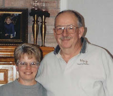
As our stay here continues, we will post some photos of Ian and his family.

Wildlife seen today:  1 porcupine, 1 snowshoe rabbit, 8 Dall sheep

Monday, May 30, 2011

Checking out the Drivable Lake Louise, Alaska Roads


We saw a couple of snowshoe rabbits in front of the RV this morning, and this one was kind enough to pose.

Snowshoe-Rabbit

There were boats out on the lake as we got ready to take a drive around the area.

Boats-on-Lake-Louise

Down by the lake, there is an interpretive sign about Dwight “Ike” Eisenhower coming here to fish for 1 day and ending up staying for 4 as he found it so relaxing.  This happened a few years before he became President.

Ike-Fished-Here

This is one of about 5 islands in the lake.  There are also several cabins around the lake that are accessed by snowmobile, float plane, or boat.

Island-in-Lake-Louise

Milepost 2011 indicates that the road ends at the Lake Louise rest area, but we crossed a small stream and continued about 3 miles to another stream crossing.  This was the end of the road for us as the other side is privately owned property.

End-of-the-Road-for-Us

Construction is going on building the Lake Louise Airport which is 3300 feet long.

Lake-Louise-Airport-Runway

There are several lodges in the area to accommodate fisherman in the summer and snowmobilers in the winter.  The next 2 photos are of Lake Louise Lodge.  The first photo is of the same view in Milepost 2011 on page 339.

Lake-Louise-Lodge

And this photo shows the front of the main lodge building.

Lake-Louise-Lodge-2

The Point Lodge can be seen from our campground.

The-Point-Lodge-on-Lake-Lou

We stopped for a pop at the Wolverine Lodge and asked questions about the area, then continued on our way.

Wolverine-Lodge

This snow groomer was parked at an area business.

Snow-Groomer

And this airboat was parked in the same lot.

Airboat

Just who is the Left Shoe Gang?

Left-Shoe-Gang

We found out that I have 2 more lakes in Alaska.

Jans-Lakes

After resting a short while, we went for a walk along the beach.  Here’s a photo of 3 of the islands.

Islands-in-Lake-Louise

And there are several cabins along the shore.

Cabins-Along-the-Lake

At one point on the beach, we found this sign.  Actually, it’s 2 signs; one is facing the lake and the other is facing shore.

What-Lies-Beneath

It made us wonder what lies beneath the surface of this beautiful lake.

What-Lies-Beneath-2

Well folks…that concludes our tour for today.  Thanks for joining us!

Sunday, May 29, 2011

Kenny Lake to Lake Louise, AK

This morning was a travel day and we only had a little over 80 miles to go so we weren’t in too much of a hurry.  I had most everything in the RV ready to travel and while Ken was eating his cereal, I was just doing something on the computer.  I happened to look up at the front window and all I could see was a large moose covering pretty much all of the viewing area.  I got up to grab a camera and asked Ken to get his and as I looked out the window, I saw that she had twins.  Once again, the cameras were too slow, but we got these shots as they retreated to cross the Edgerton Highway.

Moose-in-Camp


Moose-in-Camp2


Moose-in-Camp-3


Moose-in-Camp-4

With that excitement over, we finished packing up, dumped, and filled the fresh water tanks and were on the road.  We stopped at the junction of the Richardson Highway and the Glenn Highway to add more diesel to the tank at $4.89 a gallon.  It could be better…a lot better!  We continued west on the Glenn Highway to about milepost 2 where we found a grocery store to pick up some necessary groceries to get us to Eagle River.  About 30 miles from the junction, we arrived at our turn onto Lake Louise Road and we headed north for a little over 17 miles.

Lake-Louise-Road-Junction

Although it is in the middle of Memorial Day weekend, we found a campsite and we’ll be here until Tuesday morning.

Lake-Louise-Campsite

After getting set up in our site, we walked over to the other part of the campground and back…probably about a mile.  The were some informational signs down by the lake…I’ll take some photos and post more about that tomorrow.

In addition to the 3 moose, we saw a porcupine and a snowshoe rabbit today.

Saturday, May 28, 2011

A Day Trip to Chitina and the McCarthy Road

We packed our lunch and headed east on the Edgerton Highway this morning.  Approximately 14-15 miles from the campground, we came to a north facing viewpoint with a view of the Copper River.Copper-River-1


Our next stop was into Liberty Falls State Recreation Site for a view of Liberty Falls which can’t be seen from the main road.  This photo was taken from the bridge in the camping area.

Liberty-Falls

We found this sign about the fee structure humorous.  We had to look around and see if anyone was timing us!

Fee-Sign

This cut in the rock is the beginning of McCarthy Road.  Trains used to travel through here between Kennicott and Cordova.

McCarthy-Road-Begins

From the bridge crossing the Copper River, Ken took this photo of the fishwheels along the shoreline.  It’s not very busy now, but the season opens on June 3rd and there will be lots of activity after that.

Fishwheels-on-Copper-River

We worked our way down to the river to eat our lunch and watch the small amount of activity.  Some of the fishwheels were in place in the river and turning, but were missing the boxes that hold any fish collected in the buckets.  Here’s a closer photo of one of them.

Fishwheel-Closeup

After finishing lunch, we continued east on McCarthy Road and entered Wrangell – St. Elias National Park and Preserve.

Entering-Natl-Park

We continued a little over 17 miles on the road, turning around after crossing the one lane Kuskulana Bridge.  The former railroad bridge is about 525 feet long and 238 feet above the river and was built in 1910.

Kuskulana-Bridge

Crossing the bridge.

Crossing-the-Bridge

This next photo was taken from the bridge looking down at the river.

Looking-Down-at-the-Kuskula

Headed back toward Chitina, the roadsides are covered with blossoming lupine.

Lupines-in-Bloom


Lupines-In-Bloom-2

Back in Chitina, we drove south on the Copper River Highway to a river crossing.  At this point, the road closes in one mile and is only accessible by ATV…not hardly worth unloading for that short distance.

Copper-River-Highway-Closed

Back in town, I took a few photos of some of the historic buildings some of which are still in business.

The Chitina Emorium.

Chitina-Emporium

Spirit Mountain Artworks

Spirit-Mountain-Artworks

Hotel Chitina

Hotel-Chitina

We stopped for a beer at Uncle Tom’s Tavern (no photo), then continued back toward camp, stopping at approximately milepost 15 to take some photos of these yaks.  The Milepost 2011 indicates they may be offering tours this year; however, there were no signs to indicate that.

Yaks-1


Yaks-2


Yaks-3

Tomorrow, we plan to drive to Lake Louise State Recreation Area.  Hopefully it won’t be full considering it’s Memorial Day Weekend.

Friday, May 27, 2011

Valdez, AK to Kenny Lake, AK

We left Allison Point Campground this morning, and before heading back north, we stopped in town to take on some fuel.  The service station at Airport Road is the least expensive in the area and $.10 lower than in town, but still not what I would call a good price.  We had to go slow getting out of their lot as it has a lot of potholes in it.  We headed north on the Richardson Highway and stopped at Worthington Glacier which is at about milepost 29.  Here are 5 photos taken there…it still wasn’t too easy to get around there as there is still lots of snow on the walking trail.  It might be better for the next group as a group of young men wanting to hike on the glacier took the snow shovel and offered to actually use it to clear some trails.

Worthington-Glacier-1


Worthington-Glacier-2


Worthington-Glacier-3


Worthington-Glacier-4


Worthington-Glacier-5


At milepost 82.5, we headed east on the Edgerton Highway toward the Wrangell Mountains.

Eastbound-on-Edgerton-Highw


It wasn’t too long before Ken spotted this black bear.  It didn’t pose for photos too long before going back into the trees.

Bear-Front


Bear-Back


We got situated in our campsite, then took care of some of the household work that stacks up.  Before dinner, we drove up the Old Edgerton Highway to the Richardson Highway, then south to the Edgerton Highway and back to camp.  Ken pointed out this unusual trailer he saw on the way to camp earlier today.  It appears to be a single wide mobile home encapsulated with rocks attached as though they were bricks.  I guess it must be for the insulation factor.  While out on our drive, we also saw a trumpeter swan.

Rock-Trailer

And with that, we are back at the RV for dinner and relaxing.